On May 20, 2026, a significant meeting was held at the university with the Hero of Kazakhstan, the People's Hero, the cosmonaut pilot, the third cosmo Read more
Quotation gallery
The job of an educator is to teach students to see the vitality in themselves.
Joseph Campbell
Faculty News
On April 25, the 18th Republican Subject Olympiad in the field of Law was held at the Caspian University, bringing together the strongest students fro Read more
Пожароопасный сезон в лесах СКО в самом разгаре. Правила обращения с огнем и любовь к природе – первоосновы воспитания наших маленьких сограждан. В ра Read more
On April 17, 2026, as part of the Week of Science, the role-playing game «Court in a Criminal Case» was held. The event was held as an open criminal t Read more
On April 17, 2026, a solemn ceremony was held at Kozybaev University to award personalized scholarships dedicated to the legacy of Alexander Sergeyevi Read more
On April 16, 2026, at the Faculty of History, Economics, and Law, a solemn ceremony was held to equip the certified 1C-Accounting center with modern c Read more
On April 10, 2026, the Faculty of History, Economics, and Law hosted a session titled «Legal and Socio-Economic Aspects of Society's Development in th Read more
Гранты Read more
The M. Kozybayev North Kazakhstan University hosted the International Scientific and Practical Conference «Kozybayev Readings 2026», dedicated to the Read more
On April 8, 2026, the educational programs developed by the Academy of the International Financial Center «Astana» were officially transferred to the Read more
Remote sensing of the Earth in order to determine the degree of soil fertility for solving the problems of point farming
Priority area: sustainable development of the agro-industrial complex and safety of agricultural products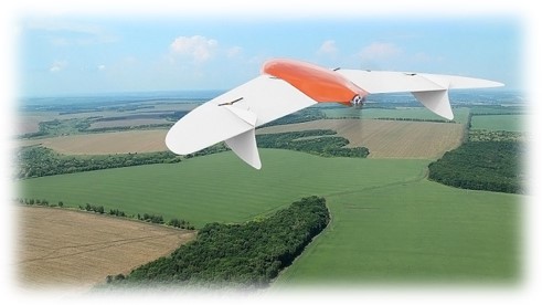
Project Manager: Sartin S.A., PhD.
Project performers: ruder V.P., master, Shchukina V.N., master, Fomin I.A., master, Ponomarenko A.S., master, Makhov I.A., master.
Deadline: 2018-2020
Amount of funding: 95,100,000 tenge.
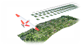
Project objective: to Develop a methodology for determining the degree of soil fertility (for the presence of the main mineral composition in sufficient quantities). Obtaining data from remote sensing of the Earth (from space and by aerial photography) in various spectral ranges and processing them using geoinformation systems and developing a methodology for determining the degree of fertility of arable land using remote sensing data.
Expected result: The accumulated data on the research direction will be entered into the geo-information environment "Geoportal". Access to information in a graphical representation with the ability to get accurate digital data, make adjustments and additions remotely, and get data online. The results of the study can be used directly for the introduction of precision farming methods in agriculture.
Project description: Currently, work is actively underway in the field of remote sensing of the earth (ERS) using modern geodetic equipment, as well as unmanned aerial vehicles (UAVs). It is planned to obtain an extensive database of spectral images of the main types of soils suitable for agriculture. From the obtained images, select the reference wavelengths related to useful elements. In the future, develop a method for determining the degree of soil fertility using narrow-band photometry methods. This method will make it much more efficient to assess the quality of arable land.
Project objective:
−obtaining samples of the main types of soils of the North Kazakhstan region;
−obtaining spectral images of the obtained samples;
−obtaining spectral images of soils when applying fertilizers;
−development of soil research methods;
−field testing of the obtained method;
−getting images of fields in different spectral ranges and processing them.